Provides support for reading and writing Coordinate Systems, and gives access to the GeoCalc Geodetic Registry. Included are an XML-based geodetic parameter library and a Project Manager feature that work on workflow management and data processing. It can also restrict editing access.
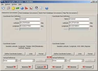
Geographic Calculator is a coordinate conversion tool that offers support for legacy ATS grid formats in addition to the existing support for Alberta Township System. There is also enhanced batch file processing features, such as a new batch interface for point data conversions and the ability to use an unlimited number of Desktop jobs in a batch conversion. These tools extend the power of the Calculator to enable geospatial data definition, manipulation and management across the user’s organization.
Comments (1)